New article on automatic forest cover classification in GEE
📢 Our latest paper, in collaboration with Katarína Onačillová and Veronika Krištofová from Univerzita ‘Pavla Jozefa Šafárika’ v Košiciach, introduces an automatic forest cover classification pipeline in Google Earth Engine to classify forest layers at country level.
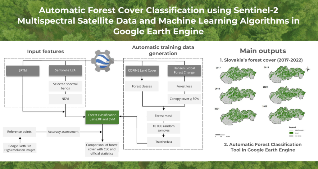
🌳🛰️ We harnessed the power of Sentinel-2 satellite data and machine learning algorithms in Google Earth Engine (GEE) to create countrywide classifications of forests in Slovakia spanning from 2017 to 2022. Since we use the aforementioned supervised classifiers, we automate the collection of training samples by generating them on-the-fly through the intersection of the CORINE Land Cover and Global Forest Cover databases. The classification is thus completely unsupervised (although you can modify the initial settings).
Read the full article, titled “Automatic Forest Cover Classification Using Sentinel-2 Multispectral Satellite Data and Machine Learning Algorithms in Google Earth Engine” in the Acta Geographica Universitatis Comenianae journal.
Key findings and outputs:
👉 Random Forest outperformed Support Vector Machine, achieving an overall accuracy of 95% in both test years (2017 and 2020) with an F1-score of up to 0.95.
👉 Forest cover in Slovakia exhibited an increase, particularly notable during 2017-2019, with a slight decrease observed between 2019 and 2020.
👉 The current forest cover identified by satellite data was lower compared to official statistics.
🗺 Whole-country forest layers for Slovakia for 2017-2022.
🛠️ We’ve developed an automatic tool for forest cover classification. The code was made open-access and is available on GitHub for everyone interested in applying it to other areas and dates, testing, or further development: https://github.com/palubad/Automatic-Forest-Classification-GEE